


Nepal earthquake "damaged Main Himalayan Thrust fault"
⊕ "Rupture stopped halfway at 11 km under Kathmandu"
⊕ "Stop is temporary, further rupture is yet to happen"
⊕ "Rupture up to the surface in one go will cause earthquake of similar magnitude to April 25"
KATHMANDU: The massive earthquake that struck Nepal on April 25 ruptured the Main Himalayan Thrust fault, but not all the way to the surface, according to a recent paper published in Nature Geoscience.
Therefore, further rupture of the fault, which stopped halfway at 11 kilometre under Kathmandu Valley, cannot be ruled out. Rupture up to the surface in the future -- as the Indian tectonic plate gradually slips under the Eurasian tectonic plate -- means reoccurrence of tremor(s) of magnitude comparable to the April 25 seismic event, one of the lead scientists warned.
A team of scientists led by J. R. Elliott and R. Jolivet had carried out a study on the Gorkha earthquake, and had submitted the paper to the journal on June 1 last year. The paper entitled "Himalayan megathrust geometry and relation to topography revealed by the Gorkha earthquake" was published yesterday.
The paper states that finding of study highlights a large, shallow region of the Main Himalayan Thrust, south of Kathmandu that has not ruptured in the April 25 earthquake, but is locked, and therefore still has the potential to fail seismically.
The researchers had used satellite data to analyse the impact of the seismic event on the rocks underneath.
The study suggested that shallow thrust fault flattening occurred at the depth between 5 and 15 kilometre due to the seismic events, and thereby generating about 1 m of uplift in the Kathmandu Basin and yet causing the high Himalaya farther north to subside by about 0.6 m.
"Using the high-resolution satellite images, we have shown that only a small amount of the earthquake reached the surface. This is surprising for such a big earthquake, which we would normally expect to leave a major fault trace in the landscape. This makes it a challenge when trying to find past earthquake ruptures, as they could be hidden," lead scientist Elliott of the Oxford University said in a statement.
The main fault, however, did not rupture all the way to the surface. Rupturing stopped some 11 kilometre under the Kathmandu Valley and the unbroken upper part of the fault -- which is over 50 kilometre wide -- is continuously building up more pressure over time, lead scientist Elliott of Oxford University said in a statement.
"We found that the rupture from April's earthquake stopped 11km beneath Kathmandu, and that this sudden break is because of damage to the fault from interactions with older faults in the region. This is important because the upper half of the fault has not yet ruptured, but is continuously building up more pressure over time as India continues to collide into Nepal," he added.
As this part of the fault is nearer the surface, the future rupture of this upper portion has the potential for a much greater impact on Kathmandu if it were to break in one go in a similar sized event to that of April 2015, according to him.
"There is still half of the fault -- that's going south of Kathmandu, from a depth of 11km up to the surface -- that hasn't yet broken," Elliott told BBC.
"Our hypothesis is that the abrupt stop is because the main fault has been damaged and it was held up where it intersected with other, smaller faults. But this will only be temporary."
"These earthquakes tend to happen on the century timescale, but this barrier could be pushed through on a shorter timescale. Of course, our problem is that we are not able to predict when; we can never give a date."
"If the remaining portion did break all the way to the surface in one go, according to him, it would likely produce a quake of similar magnitude to the April 25 event. "But being much shallower could have more damaging effects."
According to Elliott, the researchers have shown that the fault beneath Nepal has a kink in it, creating a ramp 20 kilometre underground. "Material is continually being pushed up this ramp, which explains why the mountains were seen to be growing in the decades before the earthquake," he stated.
"The earthquake itself then reversed this, dropping the mountains back down again when the pressure was released as the crust suddenly snapped in April 2015."
"Using the latest satellite technology, we have been able to precisely measure the land height changes across the entire eastern half of Nepal. The highest peaks dropped by up to 60cm in the first seconds of the earthquake."
Elliott added that Nepal has some of the highest mountain ranges in the world that have been built up over millions of years because of the collision of India with Asia. "But the way in which mountains grow and when this occurs is still debated," he said.
The earthquake was of local magnitude 7.6, according to Nepal's National Seismological Centre, while US Geological Survey and many other international agencies put its magnitude at 7.8.
Official records show that at least 8940 people were killed in the April 25 and its May 12 aftershock altogether.
The study has provided a model for Himalayas' growth over time, saying growth of Himalayan topography may largely occur during the ongoing post-seismic phase.
According to Elliott, the study showed that the fault beneath Nepal has a kink in it, creating a ramp 20 kilometre underground. "Material is continually being pushed up this ramp, which explains why the mountains were seen to be growing in the decades before the earthquake,” he said.
"The earthquake itself then reversed this, dropping the mountains back down again when the pressure was released as the crust suddenly snapped in April 2015,” he added, "The highest peaks dropped by up to 60 cm in the first seconds of the earthquake."
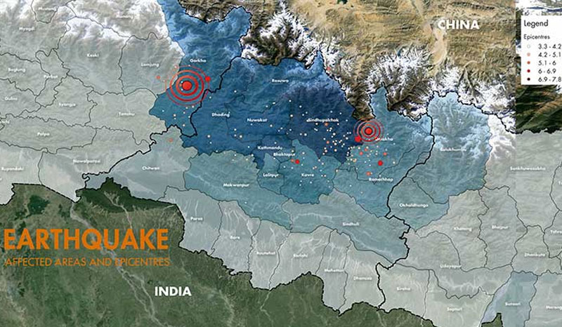
Earthquake-affected regions and epicentres. Map: ICIMOD
Himalayan megathrust geometry and relation to topography revealed by the Gorkha earthquake
Abstract
The Himalayan mountain range has been the locus of some of the largest continental earthquakes, including the 2015 magnitude 7.8 Gorkha earthquake. Competing hypotheses suggest that Himalayan topography is sustained and plate convergence is accommodated either predominantly on the main plate boundary fault, or more broadly across multiple smaller thrust faults. Here we use geodetic measurements of surface displacement to show that the Gorkha earthquake ruptured the Main Himalayan Thrust fault. The earthquake generated about 1 m of uplift in the Kathmandu Basin, yet caused the high Himalaya farther north to subside by about 0.6 m. We use the geodetic data, combined with geologic, geomorphological and geophysical analyses, to constrain the geometry of the Main Himalayan Thrust in the Kathmandu area. Structural analyses together with interseismic and coseismic displacements are best explained by a steep, shallow thrust fault flattening at depth between 5 and 15 km and connecting to a mid-crustal, steeper thrust. We suggest that present-day convergence across the Himalaya is mostly accommodated by this fault—no significant motion on smaller thrust faults is required. Furthermore, given that the Gorkha earthquake caused the high Himalayan mountains to subside and that our fault geometry explains measured interseismic displacements, we propose that growth of Himalayan topography may largely occur during the ongoing post-seismic phase.
READ ALSO:
