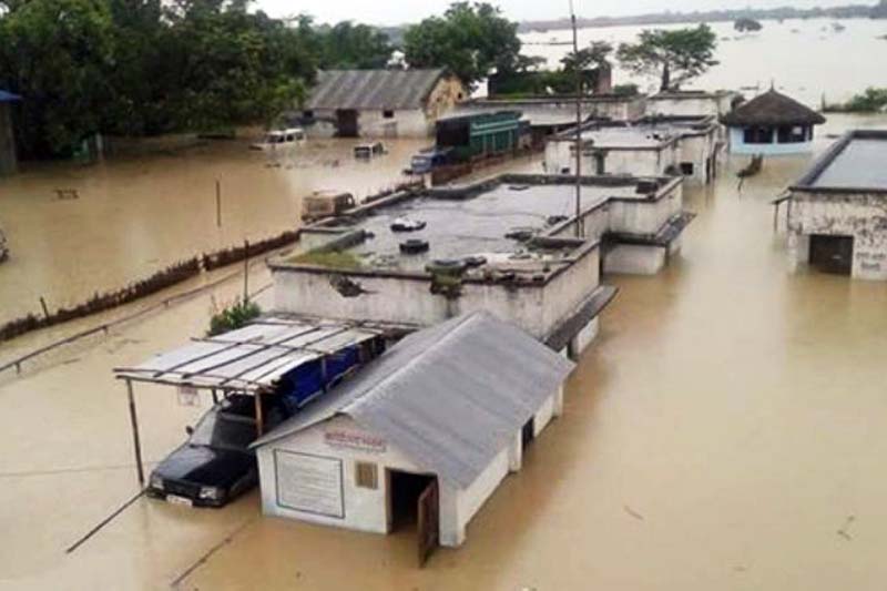
Floods wreak havoc in Tarai districts
Rajbiraj/Nepalgunj, July 26
Life has been adversely affected due to continuous rise in the water level in various major rivers in Tarai districts caused by incessant rainfall in the last couple of days.
Water flow in the Saptakoshi River was recorded 280,365 cusecs, which is the highest this season. With the water level rising, 35 sluice gates were opened and the red light was switched on at the top of the barrage.
Water level is expected to rise further as the rain has not stopped in various hill districts.
People living downstream of Saptari and Sunsari have been advised to move to safer places due to growing fear of disasters.
Meanwhile, more than a dozen villages have been inundated due to the flooded Rapti River in Banke. Various villages such as Holiya, Phattepur, Gangapur, Matehiya, Betahani, Khashkushma, Kachanapur, Baijapur, Binauna among other VDCs of the district have been submerged. “Though property worth millions has been destroyed, no human casualty has been reported so far,” informed District Administration Office, Banke.
According to Chief District Officer Rabi Lal Panth, around 200 flood victims of Holiya Chaupheri, who were stranded in the flood, were rescued by a Nepali Army helicopter today. They were rescued and taken to Khadaicha of Holiya. “All the people of Phattepur have moved to safer places,” said CDO Panth.
Water level in the Rapti River has been continuously rising. It was recorded at 7.8 metres at 6:30pm today. According to gauge reader Bhadra Bahadur Thapa, the water level has been increasing every hour. The water level in the river was measured at 7.75 metres during huge floods two years ago. According to the local administration, water starts gushing towards settlement areas on the banks of the river in Banke when the water level reaches 4.7 metres in Kusum area.
With erosion of the eastern part of Rapti bridge at Sidhaniyaghat, Kamdi; vehicular movement to and from district headquarters Nepalgunj has been completely obstructed. The Indian side has opened a few sluice doors at Laxmipur embankment, said District Administration Office, Banke.
Water level in the flooded Narayani River has crossed 10.2 metres.
Local administration has urged people to stay extra alert fearing various inevitable calamities in Chitwan and Nawalparasi.
When the water level records 8.4 metres in Narayani River, it is said to be dangerous, according to Chief District Officer Mahadev Panth of Nawalparasi.
According to CDO Panth, a large number of Nepal Police Personnel, Nepali Army and Armed Police personnel have been deployed and locals of Gandak area have been asked to stay alert. Water gates 3, 4, 5, 6, 7, 12 and 13 of the barrage are said to be at high risk of bursting. Likewise, gates 6, 7, 12 and 13 of Narsahi and 3, 4 and 5 of Paklihawa are most likely to collapse any time due to floods. All the gates of the barrage have been open for the past three days. The residents of the area have started evacuating to other places fearing catastrophe.
Scores of settlements on the banks of eastern Chitwan’s Mangalpur, Gajapur, Bhagadi, Kalabazaar, Meghauli and adjoining areas of the Narayani Rivers are at high risk with rising water level in those rivers.
Chitwan Chief District Officer Binod Prakash Singh said that they started to blow siren urging the folks to stay cautious. Nepal Police, Nepali Army and APF personnel have been mobilised in Megahuli area after the swollen rivers started eroding river banks.
A suspension bridge over Tinau River which connects Devinagar and Buddhanagar of Butwal was swept away due to the flooded river. At least five houses were swept away at Pragatinagar of Butwal. Around 11,000 squatters’ settlement on the banks of Tinau River have started to move to safer places.
Though the water level in the Bagmati and Lalbakaiya Rivers have declined, it has continued eroding the river edges. Bagmati River has eroded more than 50 bigahas land in Matsari VDC. It has also massively eroded the embankment at Badaharwa VDC in Rautahat.
According to Madhav Gautam, a local, Lalbakaiya River has eroded more than 200 metres land up to the under-construction bridge at Bhasedhawa VDC. Bagmati Irrigation Project’s western main canal is at high risk of erosion.
Jigdawa Belbichhawa, Devahi, Karuniya, Inarwa and other areas are also at high risk of erosion due to the swollen Lal Bakaiya River.
All the houses of the two wards of Banjaraha VDC were inundated when the flooded Lal Bakaiya River gushed into the village in Rautahat today.


