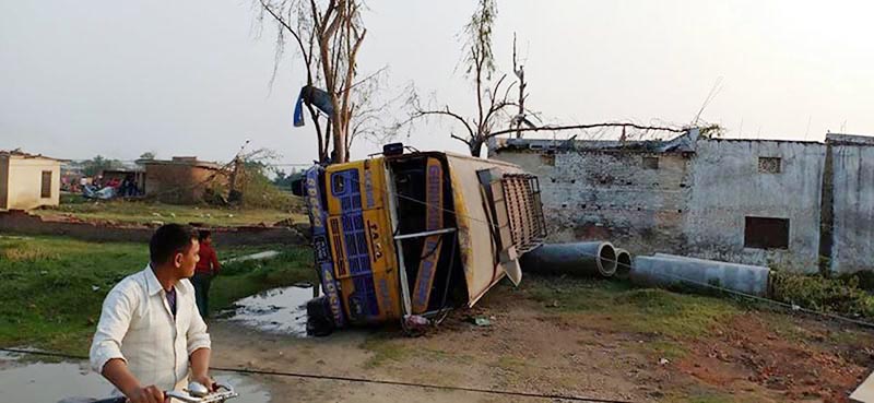
What hit Bara, Parsa last week
Kathmandu, April 6
A preliminary report made public by the Department of Hydrology and Meteorology on the recent Bara and Parsa disaster states that the devastation in the two Tarai districts was caused by a tornado. DoHM added that it was the first recorded tornado in Nepal. The department is expected to publish its full report within a few days.
The DoHM stated that its preliminary findings were based on sufficient evidence in the disaster hit areas that matched common signs of tornado.
Tornado is the worst kind of weather situation related to storm, where a cloud moving in circular motion called ‘funnel cloud’ rolls down to the surface of earth. The wind at the outer layer of such funnel clouds normally travels at speeds up to 150 kilometres per hour. The wind speed inside the funnel can be up to 200 km per hour -- powerful enough to blow away even concrete houses, buses and trees. Such funnel clouds are called tornado only after they touch the ground.
According to Madan Lal Shrestha, meteorological expert and academician of Nepal Academy of Science Technology who is leading the investigation into Bara windstorm, said the windstorm raced up to a stretch of 30 kilometres on the same path without causing any damage to structures that were even slightly away from its path, a tell-tale sign of a tornado.
Satellite pictures of disaster-hit area of Bara and Parsa showed that the storm had left a 30-kilometre-long disaster trail, while other parts of the area were not severely damaged.
“This is the most important clue, as only tornadoes among the high-velocity storms move on a certain trail,” Shrestha said. He added, “The width of the trail was around 200 to 250 metres, which is another unique feature of a tornado.”
Shrestha, who is also a former director general of DoHM, studied the disaster with the support of an organisation -- The Small Earth Nepal -- which collected satellite pictures of the area from EU’s Sentinel Satellite. The satellite records pictures of Nepal every five days. Scientists studied the pictures of the area before and after the storm.
Director General of DoHM Sarju Kumar Baidhya said, “Like a normal tornado that lasted from five to 20 minutes, the Bara and Parsa windstorm also lasted for a very limited time. But the intensity of the wind was so strong that it even uprooted trees and overturned trucks. Such devastation is possible only by tornadoes.”
He added that the intensity of the thunderstorm and the rapid hailstorm seen in the disaster-hit areas was consistent with a tornado. The DG said since the disaster struck at night, people didn’t notice funnel cloud forming in the area.
Dhiraj Pradhananga, meteorology expert and assistant professor of meteorology at Tribhuvan University, said the typography of Nepal normally did not allow formation of such rare weather situation. It is exceptionally rare case in Nepal, as formation of tornadoes needs massive amount of weather instability, he added.
Pradhananga, who is also a member of the investigation team, said the westerly wind took cumulonimbus cloud, which normally brings rain and thunderstorm in the country, from Pokhara through higher atmospheric pressure towards Bara and Parsa districts that day.
He said the weather in Bara and Parsa, which fall in plains, was hot and warm and humid air formed in the two districts with lower atmospheric pressure.
When the westerly wind carrying cool cumulonimbus clouds collided with the hot wind it led to thunderstorm, lightning and hailstorm.
He said, “As the intensity of the collision grew larger, larger funnel clouds started forming in the atmosphere.
Such funnel clouds then moved towards the surface.”
He said when such funnel clouds struck surface, they suck up everything on their path, causing devastation.
DoHM officials said that most probably their preliminary findings would be confirmed in the final report.
This means Nepalis will have to be more alert and the government needs to put in place mechanism to deal with such rare weather conditions in the future.


