Govt told to intensify bid to resolve border dispute
Kathmandu, January 2
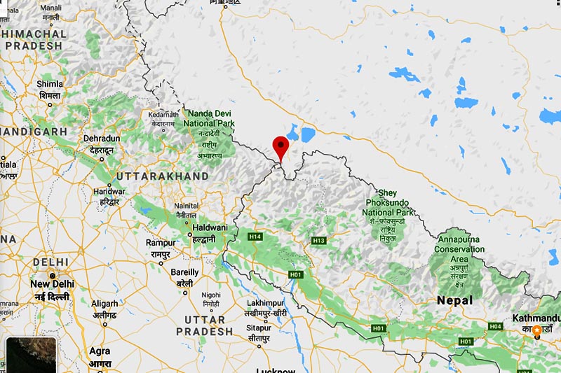
The National Assembly today unanimously adopted a stricture, directing the government to intensify the ongoing diplomatic initiative and launch high-level political efforts to resolve Nepal-India border dispute in the Kalapani region.
Proposed by ruling Nepal Communist Party (NCP) NA Chief Whip Khim Lal Bhattarai and supported by main opposition Nepali Congress NA Chief Whip Sarita Prasain, the stricture also directed the government to take to logical conclusion the initiative taken by Nepal-India High-Level Technical Committee on resolving border-related issues.
Presenting the stricture in the House, Bhattarai said the entire nation’s attention had been drawn towards the recently-published Indian political map that depicted the Kalapani region comprising Limpiyadhura, Lipulekh and Kalapani as Indian territory.
“Against the backdrop of unprecedented national unity, we table this stricture to make
sure the government takes stronger diplomatic and high-level political initiatives to keep Nepali land free of encroachment and to ensure Indian security forces stationed in the Kalapani region are withdrawn,” said Bhattarai presenting the stricture in the House.
He said Nepal was claiming the Kalapani region as its territory not on the basis of arguments, but on the basis of historical facts and proofs. “As per the international river principle, the Mahakali River’s origin is Limpiyadhura and the region on the eastern side is Nepali territory,” said Bhattarai.
Prasain said the government should hold dialogue with India based on historical facts and proofs. “We present this stricture jointly as we rise above partisan interests on an issue as sensitive as national boundary,” she said.
Nepali Congress lawmaker Radheshyam Adhikari said Nepal-India relations were multi-dimensional and that the government needed to ensure Nepal’s relations with India were not jeopardised while trying to resolve border-related issues.
In his reply, Minister of Foreign Affairs Pradeep Kumar Gyawali said Nepal-India borders were determined by the Sugauli Treaty of 4 March 1816 and three other subsequent treaties.
According to Gyawali, the Sugauli Treaty map determined Nepal’s border on the eastern (Mechi River) and western sides (Kali River), whereas the treaty of 8 December 1816 determined Nepal’s borders on the southern side (from Koshi River to Rapti River). The treaty of 1823 ensured Nepal got back Banke, Bardiya, Kailali and Kanchanpur, and the treaty of 7 January 1875 determined Daduwa watershed of Dang as Nepal-India border.
Gyawali said several maps — Sugauli Treaty-era map, 1827 map prepared by British Survey of India, 1844 Almora map, 1850 Kumaon-Garhwal map and 1856 map — proved that Limpiyadhura was the origin of the Kali River. He said after the 1950s, India renamed the Kali River as West Kali and designated another river originating from Lipulekh, some 50 km east, as the Kali River. It shifted the border further 17-18 km east by determining another river as Kali River by placing Lipulekh and Kalapani on the western side, added Gyawali. “This way, Nepali land was encroached upon, first in the map and then physically by stationing security forces in 1962,” said Gyawali. “However, none of the successive Nepali governments has agreed to that map,” he added.
Gyawali said Nepal had forwarded a diplomatic note to India on November 20 requesting it to hold dialogue and India responded positively on December 19. “India has acknowledged the problem and has expressed urgency to solve it,” he said. “We are working on a mutually-convenient date to hold dialogue. The government is confident the issue can be resolved through diplomatic efforts,” added Gyawali.
READ ALSO:


